
Ice, Ice, Baby – a cache exploring landscape change as a result of glaciation
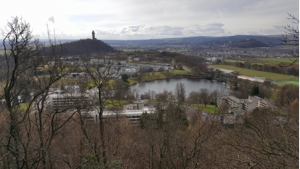
Our geocache* is situated in the Hermitage Woods behind the University of Stirling, at a spectacular viewpoint of Stirling Castle and the Gargunnock Hills. Scientific knowledge is developed and applied at a local landmark and its surrounding area, taking advantage of the unique geological features of the site.
SCIENCE + SUSTAINABILITY
The cache aims to give pupils an idea of how the landscape they look out onto was formed through glaciation, discussing scientific ideas such as glacier formation, rock erosion, and states of water. Questions within the cache aim to develop scientific knowledge in these areas, and questions are set up so that knowledge gained from discussing one question/activity can be applied to solving the next.
Teacher notes and relevant fact sheets are included within the cache in order to facilitate easy access to learning from first level through to fourth (a handful of which have been provided at the end of the blog). Cache activities conclude with pupils considering how raising temperatures would affect global sea levels, after learning about how glaciers form and melt with global temperature changes. Extra thinking points are provided, including what might cause temperatures to rise, and what could be done to minimize rises. These aspects allow links to be made to sustainability through climate change, but are introductory points which can be further developed and researched in class alongside appropriate topics with curricular experiences and outcomes such as renewable energy and energy sources. Learning can also be made more contextual and relevant to pupils at a local level through optional extended activities in which they evaluate how rising sea levels caused by climate change would impact their local area, using web resources provided in the cache activity sheet.
PLACE SENSITIVE LINKS
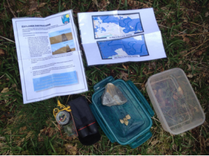
The cache is place-sensitive, using the viewpoint to allow pupils to look over the landscape through binoculars and better visualize how the glacier over the area would have changed over time. Pictures in the cache arranged in a storyboard further aid this. Maps of the area are also provided and when completing activities, pupils use the maps to look out onto the landscape, identify features on the maps that they can see, and determine how erosion and sea level rise would affect them, making place-sensitive links. Rock samples from the high and low ground pupils observe are provided within the cache, allowing them to query and investigate why such differences in the height of the landscape exist. Working together, they must apply their scientific knowledge to determine which of the rocks is stronger, and how the glacier event would have effected them, leaving the landscape which we see today.
CACHE CONTENTS AND ACTIVITY WALKTHROUGH
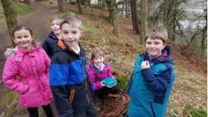
On finding the cache, pupils opened it to find an explorer task sheet with accompanying pictures, as well as two rock samples with binoculars and a compass. They were able to use the compass and binoculars to identify Stirling Castle, the surrounding Hills and the farmland below thus contrasting the high and low ground. Pictures in the cache and prompting by the adults through the use of the teacher notes when required aids the visualisation of a large glacier covering the landscape. Pupils wondered why a once flat and ice-covered landscape was now low ground with starkly contrasting steep hills left behind. This was answered using samples of rock in the cache, taken from the high and low ground spots pupils observed. By rubbing the rocks, they were able to identify that one was crumbly whilst the other was tough. They then applied their learning by suggesting the glacier caused the weaker rock to erode, whilst the tougher rock stood strong, leading to the mixture of steep hills and lower ground left today. Following this, we explored how the glacier would disappear, what would happen to the moisture, and where it would travel. Using ideas like picturing ice dropping into a bathtub, and the effect it would have on water levels, they were able to determine that the ice would melt and lead to sea level rises.
Pupils then looked at maps with the viewed points highlighted, and how different sea level rises would affect them, effectively turning the castle rock and hilltops into an archipelago. The maps contained within the cache clearly mark which areas from the viewpoint would be underwater and which would not. This all came together and linked to the global issue of climate change by posing the question ‘What would happen to areas covered in glaciers today if temperatures rose’, and ‘Which areas would be most affected’ bearing in mind what we had done today. Pupils were able to determine that sea levels would rise due to melting of glaciers if temperatures rose, and that low elevation areas would be in the most danger (as shown by the maps and viewpoints). Thinking points were shared which they could then take back to class, including ‘what might cause temperatures to rise’ (with prompts such as how we get our power and energy) and ‘what can we do to help?’ Broad aspects like this can be researched and developed in class if pupils show further interest in the topic.
Experiences and Outcomes (Curriculum for Excellence – Scotland)
The following are a handful of Experiences and Outcomes linked into the contents of our Geocache:
Early/First Level:
- By investigating how water can change from one form to another, I can relate my findings to everyday experiences. SCN 0-05a / SCN 1-05a
- Exploring properties and sources of materials. SCN 1-15a
Second Level:
- I can apply my knowledge of how water changes state to help me understand the processes involved in the water cycle in nature over time. SCN 2-05a
- Having explored the substances that make up Earth’s surface, I can compare some of their characteristics. SCN 2-17a
Authors: Jonathan Scotland and Daniel Martin – 3rd Yr Primary Education Students – Environment specialism.
* This geocache was a temporary way-marked cache – it will not be available on geocaching.com
